Mississippi River rises past 31 feet, closes roads at St. Catherine Creek National Wildlife Refuge
Published 3:01 pm Monday, January 10, 2022

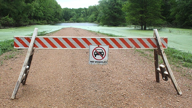
- Visitors and hunters are asked to heed warnings and signs like this as the Mississippi River begins to flood St. Catherine Creek National Wildlife Refuge. It will eventually flood Cloverdale, Sibley, Butler Lake and Cottonmouth Units. Access at the refuge begins to be limited when the Mississippi River reaches a stage of 31 feet. (Hunter Cloud | The Natchez Democrat)
|
Getting your Trinity Audio player ready...
|
SIBLEY — St. Catherine Creek National Wildlife Refuge Manager Skye Kreisler said the refuge would need to close some roads to public access due to the Mississippi River rising. Roads to Gillard Lake and Butler Lake are closed due to high water levels.
Kreisler said the water made the road to the boat launch at Gillard Lake impassable. Floodwaters have covered the boat launches at Butler Lake and Salt Lake. An old boat launch on Cabin Road near Butler Lake is accessible, but the water has to come up more for a hunter to launch a boat from it, she said.
St. Catherine Creek National Wildlife Refuge bases the closures on the Mississippi River forecast. Closed areas will not open again until the river goes down. Flooding at the refuge occurs when the Mississippi River rises to 31 feet.
Butler Lake’s first gate on Hutchins Landing is open, but the second one at Cabin Road has been closed.
“We closed that gate because once the water goes over the road, you can’t turn around if they see water up ahead,” Kreisler said. “It could prevent people from having a good turnaround, so we just close the gate.”
Wood Duck Lane’s parking lot is open. Turnip Patch Hill ATV trail is open. West ATV trails and Homochitto ATV trail may become impassable soon. Hunters and visitors are asked to turn back if the water is creeping over the road. Magnolia Hiking Trail is open (no hunting zone).
High water at the refuge could make access easy from public waterways such as the Mississippi River or the Homochitto River. However, hunters can not access the refuge from public waterways. Hunters must launch boats from the refuge and return.
Eventually, all ATV Trails and hunt units will experience flooding at St. Catherine Creek. She said Bayou Cocodrie National Wildlife Refuge has not experienced road closures or flooding this hunting season.
Waterfowl season ends on January 31, so time is running out for water levels to drop for hunters to have access. Kreisler said the refuge has tried to be optimistic but must consider public safety too.
“I want to be proactive and help keep visitors safe,” Kreisler said. “They need to heed the signs and warnings. Keep an eye out for flood water, river levels and road conditions, be smart.”
St. Catherine Creek National Wildlife Refuge’s Facebook page is called Lower Mississippi River Refuge Complex. People can visit the page to get updates on refuge conditions, closures and other information about the refuge.


